Dalbandin Airport - Photos by Aroosh Naqvi

Share photos of PIA, Pakistani airlines, Pakistani airports and photos related to civil & military aviation of Pakistan.
User avatar
Abbas Ali
Site Admin
Posts: 56825
Joined: Thu Aug 05, 2004 6:52 pm
Location: Pakistan

Dalbandin Airport - Photos by Aroosh Naqvi

Post by Abbas Ali »

Photos of Dalbandin Airport with information by First Officer Aroosh Naqvi (forum member AN).

Image
Finals at Dalbandin Airport (DBA), possibly the remotest airport PIA operates into. It is also the highest elevation 3120 feet, with a runway of only 1524m and a minimal width of about 75 '.

Image
ASSL also operate their Fokker F-27-500 (AP-BHZ) into DBA, After flying both aircraft, and doing a careful comparison, the ATR is 39% faster in cruise than the F-27, and 33% more fuel efficient than the F-27. However in my opinion, the F-27 had a character about her that the ATR simply cannot match. Good to see her still in operation around Pakistan and in such good condition too. The example in the picture is one of the last off the production line in the late 80s, and is kept a lot cleaner than PIA's ATRs.

Couple of bonus photos

Image
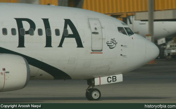
PIA Boeing 737-340 (AP-BCB) taxiing at Karachi Airport.

Image
PIA ATR 42-500 static ports.

Thank you Aroosh for sharing excellent photos!
Dil Dil Pakistan... Jaan Jaan Pakistan

See you at:
Image
Moin
Registered Member
Posts: 3165
Joined: Sun Aug 08, 2004 11:17 am

Post by Moin »

Where exactly is Dalbadin?
Moin Abbasi
User avatar
Abbas Ali
Site Admin
Posts: 56825
Joined: Thu Aug 05, 2004 6:52 pm
Location: Pakistan

Post by Abbas Ali »

^ It's in Balochistan province, not very far from Chagai.

Image

Source: www.met.gov.pk
Dil Dil Pakistan... Jaan Jaan Pakistan

See you at:
Image
User avatar
chevron
Registered Member
Posts: 389
Joined: Sun Apr 02, 2006 8:36 am
Location: Troposphere

Post by chevron »

Finals at Dalbandin Airport (DBA), possibly the remotest airport PIA operates into. It is also the highest elevation 3120 feet, with a runway of only 1524m and a minimal width of about 75 '.
Please correct me if I am wrong, Dalbandin Airport may be the remotest field but it isn't the highest elevation. There are many other airports with higher elevation, to name a few:

Skurdu = 7316 feet, 2230 meters
Quetta = 5267 feet, 1605 meters
Chitral = 4920 feet, 1500 meters
Gilgit = 4796 feet, 1462 meters
Zhob = 4728 feet, 1441 meters
Panjgur = 3289 feet, 1002 meters
Saidu Sharif = 3183 feet, 970 meters

Source: Image
The airplane stays up because it doesn't have the time to fall. - Orville Wright
History is not history unless it is the truth. – Abraham Lincoln
AN
Registered Member
Posts: 685
Joined: Fri Aug 06, 2004 7:05 pm

Post by AN »

Very right, i meant to say it is amongst the highest that PIA operates into. thanks for the correction.

Skardu is probably the highest.
User avatar
atmalik
Registered Member
Posts: 1192
Joined: Fri Mar 11, 2005 8:29 am
Location: USA

Post by atmalik »

Two questions:

What is ASSL??

And

What kind of load factors do you have on the Dalbadin flights and whats the frequency?
User avatar
Abbas Ali
Site Admin
Posts: 56825
Joined: Thu Aug 05, 2004 6:52 pm
Location: Pakistan

Post by Abbas Ali »

atmalik wrote:Two questions:

What is ASSL??
Aircraft Sales & Services Limited (ASSL) based at Karachi Airport.

For details visit their website www.asslpk.com.
atmalik wrote:..... on the Dalbadin flights and whats the frequency?
Once a week, ATR 42 flight PK-521/522, operated every Thursday on Karachi-Gwadar-Turbat-Dalbandin-Karachi route.

Abbas
Dil Dil Pakistan... Jaan Jaan Pakistan

See you at:
Image
User avatar
Adnan Anwar
Registered Member
Posts: 967
Joined: Thu Aug 05, 2004 8:52 pm
Location: Toronto, ON

Post by Adnan Anwar »

What are static ports?
Adnan Anwar
User avatar
Abbas Ali
Site Admin
Posts: 56825
Joined: Thu Aug 05, 2004 6:52 pm
Location: Pakistan

Post by Abbas Ali »

^ Static ports are used to drive air-speed indicator, vertical speed indicator and altimeter on cockpit instrument panel.

For more info: Static Ports - Wikipedia

Abbas
Dil Dil Pakistan... Jaan Jaan Pakistan

See you at:
Image
virk
Registered Member
Posts: 255
Joined: Mon Jul 17, 2006 11:11 am
Location: Lahore

Post by virk »

I dont see no fire truck at the airport :o :o
User avatar
Abbas Ali
Site Admin
Posts: 56825
Joined: Thu Aug 05, 2004 6:52 pm
Location: Pakistan

Post by Abbas Ali »

^ Scheduled passenger flights cannot be operated to/from an airport without proper fire fighting and rescue system/vehicles.

Here's larger image showing fire tender at Dalbandin Airport and the white vehicle looks like CAA ambulance to me.

Image
Dil Dil Pakistan... Jaan Jaan Pakistan

See you at:
Image
User avatar
Adnan Anwar
Registered Member
Posts: 967
Joined: Thu Aug 05, 2004 8:52 pm
Location: Toronto, ON

Post by Adnan Anwar »

Abbas Ali wrote:^ Scheduled passenger flights cannot be operated to/from an airport without proper fire fighting and rescue system/vehicles.

Here's larger image showing fire tender at Dalbandin Airport and the white vehicle looks like CAA ambulance to me.

Image
Is Dalbandin airport, the same airfield that was used to land the C-130 that was transporting the nuclear devices in 1998 for Pakistan to explode them llater at Chagai Hills. From Abbas Ali's map, the Chaghai Hill seems to be in a very close vicinity.
Adnan Anwar
User avatar
Abbas Ali
Site Admin
Posts: 56825
Joined: Thu Aug 05, 2004 6:52 pm
Location: Pakistan

Post by Abbas Ali »

^ When Pakistan's nuclear tests were conducted in 1998, two names gained prominence: Chaghai Mountain and the airstrip of Dalbandin. Dalbandin is located among sand dunes some 30 km south of the Chagai Hills near the Afghan border. Pakistan's nuclear tests were conducted inside a mountain range near the border with Iran and Afghanistan. The Ras Koh mountains, the site of Pakistan's nuclear test, are south of Dalbandin. On 19 June 1998 Prime Minister Nawaz sharif visited the nuclear test site in Pakistan's rugged southwestern Balochistan province. Before arriving at the test site, Prime Minister Sharif addressed a cheering crowd in the nearby village of Dalbandin.

Above info source + more on following link:

Link: Dalbandin - GlobalSecurity.org
Dil Dil Pakistan... Jaan Jaan Pakistan

See you at:
Image
pk363
Registered Member
Posts: 776
Joined: Mon Dec 31, 2007 8:07 am
Location: Dubai, UAE

Post by pk363 »

The flights to Dalbandin remained suspended for many years. Infact there is very little local demand as this is one of the poorest area in Pakistan. There are two world's largest copper mines in this area, Saindak and Reko Diq. Infact the resumption of flights is because of a lot of expats movement to and from these copper prospects. Saindak in production phase while Reko Diq under feasibility. Later is owned by a JV of Chillian and Canadian firms.

I was a consultant on Reko Diq to source water for mine in 2004 and 5. It takes up to 10 hours to travel from Quetta to minesite by road. With law and order situation very bad enroute, PIA was requested to start service. In addition they also very frequently operate chartered flights as most of the national staff and equipment is also by air these days.
User avatar
Abbas Ali
Site Admin
Posts: 56825
Joined: Thu Aug 05, 2004 6:52 pm
Location: Pakistan

Post by Abbas Ali »

From 'Oxford Atlas For Pakistan', here's scan of a page showing location of Dalbandin, Ras Koh mountains and Chagai.

Image
Dil Dil Pakistan... Jaan Jaan Pakistan

See you at:
Image